


62 Ymiden 720 – Charting from the Skies
It felt like a weight had been lifted off him. He was going to be charting from the skies.
For all of his days of mapping, Brent had never truly considered the idea of being able to scout out the land and conduct his mapping from the air. He had listened in amazement when his cousin Jasper had spoken of owning a Sleipnir, despite not being part of the Ragnari. At the time, he had masked his hint of jealousy with the strong desire to do it the ‘proper’ way. And also at the time, the idea of being so far from the ground with only a good strong gust of wind to knock you off and send you falling… It was an idea easily dismissed as ‘impractical’. The second time he had considered the idea of flight in his charting was when Navyri offered to sketch the land from above. Again, he provided a steady stream of reasons why it would be impractical and potential pitfalls that she would have to look out for including a poor sense of scale and being unable to see forest trails through the trees.
Apparently, he had come around to the idea.
Sinir, the winged horse that was the catalyst for this new way of mapping, was saddled and ready with a few basic supplies, like food, for the journey. In addition, Brent had a leather bag with a shoulder strap containing several of his previously constructed maps, blank sheets of parchment, and several writing implements including charcoal sticks, pens, and ink. His relationship with the Sleipnir was still a bit rocky, as his mount was both spirited and cautious about trusting a new rider, but they had made some progress over the last season.
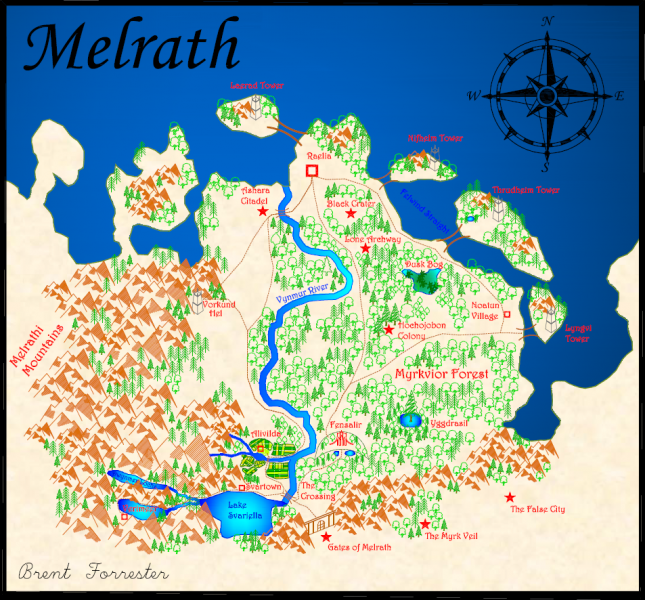
The morning was still fresh when Brent mounted Sinir in the small village of Svartown and took off at a trot. With a firm kick, he encouraged the Sleipnir faster as he bent low in the saddle. Leaning slightly backwards and tilting the reins so that the winged horse would face the sky, Sinir’s wings opened and with a flurry of wind, they were up in the sky.
Higher and higher with each powerful beat of the Sleipnir’s wings they soared. After gaining some elevation, Brent guided the winged horse to face south with a firm tug of the reins. Soon they were over luscious blue waters of Lake Svariella. Warm wind buffeted his hair and the cartographer kept his eyes peeled on the shorelines, doing his best to memorize the exact shape for when he could sketch it out.
As he veered to the right, such that he could look on towards the Dwynmer Lochs, he recalled the adventures of last season where he had been charting the region on foot. This was the key reason for his current expedition. Although he had detailed maps of the trails below and also the towns across Melrath, he needed to solidify it with accurate coastlines and any features he had not managed to capture from the ground.
Once Sinir had leveled out and was gliding more than he was flapping, Brent hugged the creature’s muscular body with his knees and very carefully took out a single sheet of parchment and a charcoal stick. Even after growing accustomed to the wind, it was not an easy feat to keep the parchment flat and secure. The thicker and heavier medium helped, but Brent was very cautious as he began making sketches of the shoreline for Svariella Lake as well as the mountain rivers that flowed into it.
A sharp turn from Sinir jolted him out of his concentration and he had to quickly grab hold of the saddle. Brent had to take a moment to reframe his point of view, using the Melrathi Mountains and Vynmur River as guides, and then continued to sketch the lake. Almost as an afterthought, Brent decided to add a north arrow to his current sketch. He lined it up with the direction his compass was showing relative to the curves of the lake. Even though for the most part he knew how the lake was situated relative to the cardinal directions, should he ever get disoriented it would help keep his features accurate by referring to the compass.
It was surprisingly chilly being so high up, and Brent was thankful that it was Ymiden and that the day was still warming up. Despite being a native Melrathi, he had rarely explored the lands of the Mer west of Lake Svariella. Swooping low, he was fascinated by the rivers and rapids and waterfalls. Occasionally he even spotted faint signs of the strange underwater people, such as their coral islands.
Despite the efficiency of charting from the air, there were going to be casualties. Brent lost his first charcoal stick a few hours in, and it splashed silently into the waters below. Fortunately, he had brought many along as they were the simplest to acquire and replace.
For the rest of the trial he focused on the waterways of southwestern Melrath. Occasionally he stopped for food and to give Sinir a rest, and a well deserved drink of water. Brent used these breaks to fine-tune his map, as it was much easier to fill in the details and solidify the lines when he wasn’t being jostled in his saddle with the wind blowing at the parchment.
When it came time to find shelter for the night, Brent slept simply. He found a fallen tree that was somewhat propped up by another tree, making a nice sturdy angle to construct a lean-to. Piling branches of evergreens along the two sides, it was suitable to sleep under for such temporary lodging.
It felt like a weight had been lifted off him. He was going to be charting from the skies.
For all of his days of mapping, Brent had never truly considered the idea of being able to scout out the land and conduct his mapping from the air. He had listened in amazement when his cousin Jasper had spoken of owning a Sleipnir, despite not being part of the Ragnari. At the time, he had masked his hint of jealousy with the strong desire to do it the ‘proper’ way. And also at the time, the idea of being so far from the ground with only a good strong gust of wind to knock you off and send you falling… It was an idea easily dismissed as ‘impractical’. The second time he had considered the idea of flight in his charting was when Navyri offered to sketch the land from above. Again, he provided a steady stream of reasons why it would be impractical and potential pitfalls that she would have to look out for including a poor sense of scale and being unable to see forest trails through the trees.
Apparently, he had come around to the idea.
Sinir, the winged horse that was the catalyst for this new way of mapping, was saddled and ready with a few basic supplies, like food, for the journey. In addition, Brent had a leather bag with a shoulder strap containing several of his previously constructed maps, blank sheets of parchment, and several writing implements including charcoal sticks, pens, and ink. His relationship with the Sleipnir was still a bit rocky, as his mount was both spirited and cautious about trusting a new rider, but they had made some progress over the last season.
The morning was still fresh when Brent mounted Sinir in the small village of Svartown and took off at a trot. With a firm kick, he encouraged the Sleipnir faster as he bent low in the saddle. Leaning slightly backwards and tilting the reins so that the winged horse would face the sky, Sinir’s wings opened and with a flurry of wind, they were up in the sky.
Higher and higher with each powerful beat of the Sleipnir’s wings they soared. After gaining some elevation, Brent guided the winged horse to face south with a firm tug of the reins. Soon they were over luscious blue waters of Lake Svariella. Warm wind buffeted his hair and the cartographer kept his eyes peeled on the shorelines, doing his best to memorize the exact shape for when he could sketch it out.
As he veered to the right, such that he could look on towards the Dwynmer Lochs, he recalled the adventures of last season where he had been charting the region on foot. This was the key reason for his current expedition. Although he had detailed maps of the trails below and also the towns across Melrath, he needed to solidify it with accurate coastlines and any features he had not managed to capture from the ground.
Once Sinir had leveled out and was gliding more than he was flapping, Brent hugged the creature’s muscular body with his knees and very carefully took out a single sheet of parchment and a charcoal stick. Even after growing accustomed to the wind, it was not an easy feat to keep the parchment flat and secure. The thicker and heavier medium helped, but Brent was very cautious as he began making sketches of the shoreline for Svariella Lake as well as the mountain rivers that flowed into it.
A sharp turn from Sinir jolted him out of his concentration and he had to quickly grab hold of the saddle. Brent had to take a moment to reframe his point of view, using the Melrathi Mountains and Vynmur River as guides, and then continued to sketch the lake. Almost as an afterthought, Brent decided to add a north arrow to his current sketch. He lined it up with the direction his compass was showing relative to the curves of the lake. Even though for the most part he knew how the lake was situated relative to the cardinal directions, should he ever get disoriented it would help keep his features accurate by referring to the compass.
It was surprisingly chilly being so high up, and Brent was thankful that it was Ymiden and that the day was still warming up. Despite being a native Melrathi, he had rarely explored the lands of the Mer west of Lake Svariella. Swooping low, he was fascinated by the rivers and rapids and waterfalls. Occasionally he even spotted faint signs of the strange underwater people, such as their coral islands.
Despite the efficiency of charting from the air, there were going to be casualties. Brent lost his first charcoal stick a few hours in, and it splashed silently into the waters below. Fortunately, he had brought many along as they were the simplest to acquire and replace.
For the rest of the trial he focused on the waterways of southwestern Melrath. Occasionally he stopped for food and to give Sinir a rest, and a well deserved drink of water. Brent used these breaks to fine-tune his map, as it was much easier to fill in the details and solidify the lines when he wasn’t being jostled in his saddle with the wind blowing at the parchment.
When it came time to find shelter for the night, Brent slept simply. He found a fallen tree that was somewhat propped up by another tree, making a nice sturdy angle to construct a lean-to. Piling branches of evergreens along the two sides, it was suitable to sleep under for such temporary lodging.